A Survey of the Buildings

Plan of the town and castle of Karak
The plan of the town and castle of Karak illustrate how the fortifications were meant to function. The whole of the plateau on which the town is located was originally encircled by a long defensive wall (the dotted lines on the plan mark in the sections of the wall that no longer exist). Towers (Arabic: burj) were constructed at points along the wall so that the defenders would enjoy maximum visibility of the surrounding countryside and the routes leading up to the town. Some of these towers still exist.

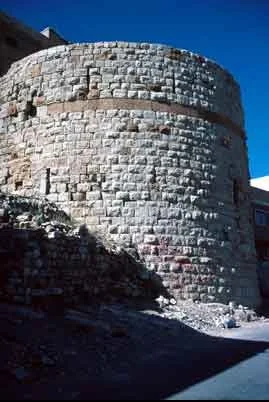
Burj al-Zahir looking southwest
The largest of these is located at the northwest extension of the city and is known as Burj al-Zāhir. An inscription on the interior of the tower states that it was built by order of the Mamluk sultan Baybars (reigned 1260-77). It is noticeable that the style of this imposing structure is very similar to that of donjon at the south end of the castle (see below).
Another one of the towers created by Baybars is the smaller round tower, known as Burj al-Banawī, located at the southeast end of the circuit. This time, the inscription is placed in a band on the upper part of the exterior.
Burj al-Banawi looking north

In addition to giving the name of the founder, it also carries two carved depictions of lions. This heraldic image appears on many of the structures and objects commissioned by Baybars, and is known to have acted as his personal emblem.
An undated tower, known as Burj al-Sā`ub employs a very different design with a machicolated parapet.

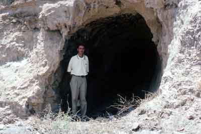
Subterranean entrance to Karak
It is clear from looking at the two towers commissioned by Baybars, and those of the remainder of the circuit, that little emphasis was placed upon employing a consistent style in the buildings. In part this can be attributed to the fact that they were the products of different patrons, but also it may be that as time progressed the design of fortifications had to take account of changes in the technology of siege warfare. Another aspect of the defences of the town were the entrances. It is not known how many gates there were into the town, but it seems likely that points of access were kept limited for security reasons. In addition, there are two subterranean passages with entrances in the escarpments near Burj al-Zāhir and northeast of Burj al-Sā`ub . The latter passage is undated, but the former has an inscription saying that it was built by order of the Ayyubid sultan al-Mu`azzam `Īsa in 1227. Such subterranean entrances were much easier to defend against attackers because they only allowed small numbers through at any one time and also could be blocked. These entrances, the defensive wall and the towers comprised the first line of defence against an attacking army. If this failed then the inhabitants of the town could flee to the safety of the castle.
In its present form Karak castle is the result of multiple phases of building over several centuries, starting with the first period of Crusader construction after 1142. The castle is separated from the town by a ditch (originally much deeper, but over the centuries gradually filled with debris).


Karak Castle north wall
The north end of the castle employs the rough-cut masonry that is a characteristic feature of Crusader military architecture. Although modern visitors pass over a bridge and through the ruined remains the the western salient (i.e. rectagular projection from the line of the wall), in the past an invading army would have been faced with the problem of bridging the ditch and then making their way (under fire from defenders inside the castle) across to the small gateway located in the eastern salient. It is typical of castles of this period that the entrance to the castle is both relatively small and awkwardly located. The placement of deep ditches at the north and south ends of the castle provided further security, but the development of ever more sophisticated machines for firing projectiles (known as mangonels or trebuchets) meant that the occupants did not live in complete safety during sieges. In the 1340s when the castle was besieged by the Egyptian Mamluk army, we find references to the first use of gunpowder and cannon in the Middle East. By the nineteenth century the advances in the technology of cannon and explosives made the fortifications of Karak redundant. Large portions of the walls were destroyed by the Ottoman army in the 1830s to stop the castle being used as a refuge for rebels against the government.
The remainder the castle includes examples of both Crusader and Muslim architecture. The main extant section of the Crusader castle is the lower terrace on the west side and the vaulted halls immediately inside the north wall. The lower terrace gave the occupants commanding views over the wādī below, and west as far as the Dead Sea. There are also the remains of a Crusader chapel in the upper sections of the castle. We know from administrative documents of the twelfth century that the lord of Karak had his own priest who presumably conducted services in this building, but there was also a cathedral in the town itself. The site of the Crusader cathedral is now occupied by the Congregational Mosque for the town. Chronicles of the Medieval period note that the Ayyubids conducted renovations in the town and castle between 1188 and 1263, but the most conspicuous remains in the castle date to the Mamluk period. After conquering the castle in 1263, sultan Baybars extensively rebuilt the south and west defences of the castle. Most impressive is the massive donjon (i.e. tower or keep) at the south end [ Photo]. Noticeable is the change in masonry style from the time of the Crusaders; here the masons of the Mamluk period have taken much more care in the shaping and finishing of each block.

Lower terrace of Karak Castle looking southwest

Palace complex of Karak Castle looking north
In the fourteenth century mamluk sultans continued to add new structures inside the castle. North of the donjon is a small courtyard surrounded by rooms that probably served as the palatial residence of sultan al-Nāsir Muhammad (reigned 1293-94, 1299-1309, 1310-41) and his successors. We know that sultan al-Nāsir Muhammad instructed his governor to build a palace, a hospital (Arabic: maristān), a religious school (Arabic: madrasa) and a parade ground (Arabic: maydān) in Karak. Unfortunately, we are no longer able to identify where these buildings were located, but the palace may well be the one that survives today in the castle. It is striking that this complex of rooms is comparatively modest in scale. This may be explained by the fact that the sultan was drawn to Karak because he enjoyed spending time with the nomadic bedouin tribes of the region (he also sent his sons here so that they could be educated in bedouin ways), and so the comforts of palatial life might have been a rather secondary consideration.
The palace complex is now rather bare of ornament, but a trace of its original appearance can be seen in a carved geometric panel located in an entrance vestibule on the east side.

Geometric panel entrance chamber east side